
Blackpool’s Iconic Pleasure Beach Resort mapped in unprecedented 3D detail to help emergency services

Blackpool’s Iconic Pleasure Beach Resort mapped in unprecedented 3D detail for the first time to aid emergency services.
One of the UK’s most famous leisure attractions - Blackpool Pleasure Beach Resort- has been mapped in 3D for the first time.
Lancashire Fire and Rescue Service (LFRS), in partnership with Ordnance Survey (OS) and the Lancashire Local Resilience Forum (LRF), has created a 3D model of Blackpool Pleasure Beach to support safer, more effective emergency planning and response.
The high resolution digital model provides unprecedented detail of one of the UK’s most complex leisure environments, enhancing preparedness for multi-agency responders.
Blackpool Pleasure Beach Resort founded 130 years ago in 1896. It attracts more than five million visitors every year, making it one of the country’s most popular attractions.
Known for its compact collection of 125 rides and attractions, the park mixes historic seaside heritage with modern rides, including The Big One — the UK’s second tallest rollercoaster at 65 metres high.
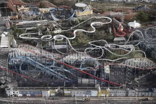

Traditional 2D plans have struggled to represent the height, depth, and complex access routes of such a dense and vertical site.
Blackpool Pleasure Beach Resort’s compact footprint, tall structures, and large visitor numbers created a challenging environment for responders, who needed precise, shared spatial understanding to plan safe access, staging areas, evacuation routes and contingency options.
OS consultants shared their expertise in UAS operations to upskill LFRS and help them maximise their UAS capability in 3D mapping.
LFRS was then able to capture high overlap aerial imagery of Blackpool Pleasure Beach using their drones and process it into a high resolution 3D mesh model of the entire site. This detailed reconstruction accurately reflected the park’s varied structures, heights, and confined spaces.
All the latest news and top stories from across Blackpool and the Fylde coast directly to your phone.
Never miss a thing. Click here to join
Tim Murrell, Drone Manager at LFRS, and the Drone & Robotics Lead at the National Fire Chiefs Council, said: "Whilst we have been operating drones for 10 years, the complexity of the site allowed us to develop our techniques in a more challenging environment.
“The expertise in UAS mapping operations provided by Ordnance Survey was pivotal in allowing us to safely and effectively map the site. The drone flights and subsequent 3D mesh generation has allowed us to better support our LRF colleagues with highly detailed mapping of a complex site.
“We are better prepared for potential incidents and scenario training, and can provide a highly visual platform for shared situational awareness."
To provide wider operational context, the model was extended beyond the Pleasure Beach by combining it with a separate 3D mesh of the surrounding town supplied by OS, creating a seamless town-wide digital environment suitable for planning, training, and multi-agency response.
The new 3D approach has brought realism and a shared operating picture that static maps simply cannot achieve.
All the latest news direct to your inbox
The 3D model assists with better operational planning; scenario modelling & training; shared situational awareness; and safety & efficiency, reducing risk to responders and strengthening value for money by re‑using the same trusted digital asset across agencies.
Kevin Topping, Chair of the LRF Lancashire Emergency Response Plan Sub Group, said: “Lancashire Local Resilience Forum has a long history of innovation. Although we have always utilised GIS data to produce static maps, the use of newer technology and applications opened up the possibility of assessing how drones could bring a new sense of realism to planning, response and recovery. This initial example, supported by Ordnance Survey, has enabled us to build on our experience and widen the scope to more sites now and in the future, both in peacetime and during a response.”
OS 3D mapping has been used by multiple organisations in real incidents around the country. Devon and Cornwall Police was assisted by OS geospatial experts for a major evacuation in Plymouth; and the Isle of Wight Council was supported following a landslip.
Chris Heap, Propositions Manager at OS, said: “Ordnance Survey has a long history of supporting emergency planning and emergency response services, so enabling the highly detailed 3D modelling of such an iconic site as Blackpool Pleasure Beach was a tremendous privilege.
“This community is increasingly investing in the use of drones for routine operations, but often needs that extra level of support and expertise that OS can provide in order to create 3D models. OS 3D mesh forms a highly re-useable and multi-purpose 3D base map suitable for a wide variety of uses from town planning through to large scale infrastructure development.”
OS 3D Mesh is a photorealistic, ready-to-use 3D basemap derived from imagery collected for the OS National Geographic Database.
It can be used within Geographic Information Systems (GIS), Computer Aided Design (CAD) tools, or specialist 3D modelling software to provide a detailed 3D view of any area of interest. The product has been developed to enable the immersive visualisation of a specific area and for detailed analysis in a wide variety of areas such as urban planning, telecoms modelling, security and flood risk assessment, as well as for security and emergency planning.