In search of the lost Roman harbour in Lancashire


One such place is the Setantiorum Portus, the harbour of the Setantii, which he located somewhere on the Lancashire coast in a sequence of place names running from south to north – Seteia, Belisima, Portus Setantiorum and Moricambe Aestuarium.
He claimed to be working to an accuracy of 1/12th of a degree of latitude – five-and-a-half stadia or Roman miles; Seteia and Belisima have eventually been identified respectively as the Mersey and Ribble, so locating the port should be a simple matter, one might think.
Advertisement
Hide AdAdvertisement
Hide AdThe Setantii, whose name is said to mean ‘people of the waters’, were probably a sub tribe of the Brigantes, who dominated northern England.
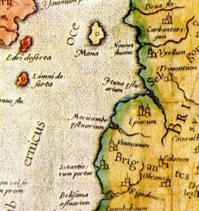
The name does seem to fit with the topography of parts of the Morecambe Bay area, in particular Over Wyre and the North Fylde, which, in the absence of sea defences, would have been a series of small islands of higher ground surrounded by an expanse of mosses and sea washed salt marshes.
However, no original map has survived and only doubtful copies remain.
There is also a major problem with the figures listed for latitudes and longitudes. Ptolemy was working with the most recent figure for the diameter of the earth provided by Marinus of Tyre, which was some 16 per cent too small, rather than that calculated in the 2nd century BC by Eratosthenes, which was only 10 per cent too large and may even have been much more accurate than that.
Advertisement
Hide AdAdvertisement
Hide AdThis error completely changes the figures given by Ptolemy; it was responsible for the unshakeable belief held by Christopher Columbus to the end of his days that he had really reached the East Indies rather than just the Caribbean, and has led to the present uncertainty over the location of the Portus.
Another problem with the figures for the British Isles is that there appears to have been two separate lists with different origins which do not quite agree with each other, one of inland and the other of coastal locations, perhaps one supplied by the Roman army and the other by the navy.
This makes it very difficult to relate known names of inland towns to locations on the coast. Also, for reasons unknown, Scotland was completely turned through 90 degrees.
Antiquarians were interested from an early date in the works of Ptolemy and the first to publish a work in English which describes his work was William Camden, whose book on Britannia appeared in 1610.
Advertisement
Hide AdAdvertisement
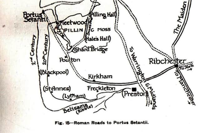
Hide AdThen in 1747, William Stukeley, also a celebrated antiquarian, came into possession of a remarkable document whose provenance appeared to be impeccable. This was the ‘De Situ Britanniae’ of Richard of Cirencester, a 14th century monk, and turned out to be a history of Roman Britain with map attached, authenticated by various authorities as being a genuine 400-year-old original. The document added new information, such as a road running from ‘Portus Sistuntiorum’ to York.
Calculations of the names and distances involved placed the Portus somewhere near the mouth of the Wyre, probably a couple of miles offshore from Fleetwood, a point identified later by others as King Scar.
It was about a century before the unpalatable fact that De Situ Britanniae was a brilliant forgery by an unknown perpetrator became generally accepted and, by that time, the damage had been done and it was too late to fully erase many of the falsehoods within it.
Some spurious place names were not finally removed from Ordnance Survey maps until the first metric editions and the notion that the Portus was offshore from Fleetwood had become firmly entrenched and has persisted to the present day.
Advertisement
Hide AdAdvertisement
Hide AdThe historians of the 19th century who entered this minefield of confusion and disinformation certainly had their hands full, but a number of contributions of varying reality began to appear, placing the Portus in a number of different places, including the estuaries of both the Wyre and Ribble.
Into the breech stepped a truly larger than life character who dominated the debate for years, the Rev William Thornber, author in 1843 of a History of Blackpool, an active, hands on investigator and prolific writer of papers on every aspect of the history of the area who became known as the Historian of the Fylde.
Six feet tall, an athlete and pugilist, he belonged to the local tradition of sporting churchmen like Parson Potter of Pilling who fought thrice and preached twice every Sunday. Thornber, it was said, would as soon knock a man down as look at him, and many felt the force of his fists. He liked nothing better than touring the area gathering local information and folklore, watching excavations and collecting artefacts.
He recorded stories of workmen uncovering the broken end of a road on the shore at Fleetwoood, which has led to endless speculation as to its destination, and recalled a circular stone structure at Rossall Point which he fancied could have been a landing place, around which, as a child, ‘it was uncanny to sport’.
Advertisement
Hide AdAdvertisement
Hide AdHe wrote of lands and villages out to the west, overwhelmed by the sea (one of which he certainly invented) and of an inn which used to stand at the Penny Stone, a mile offshore from Cleveleys.
His writings, one could say, were full of sound and fury, but sometimes a trifle unreliable, although he placed the Portus further upriver than Richard of Cirencester.
Eventually he became increasingly unstable and lost his reputation as a reliable observer, although his works were still frequently quoted by later writers.
At the end of a turbulent career he unfortunately had to be confined and, after escaping once, he was spotted by police Sgt. Whiteside watching workmen digging a trench. The unwary sergeant placed a hand on his shoulder and said “I want thee”, only to find himself flat on his back in the trench an instant later after a swift uppercut from Thornber.
Advertisement
Hide AdAdvertisement
Hide AdIn March 1860 on the occasion of the lowest tide for a century, Edwin Waugh, the Lancashire poet and writer, had walked out to the Penny Stone and there by chance encountered none other than William Thornber, who actually admitted in conversation that he had made up much of the detail in some of his writings.
Eventually John Just, who had accompanied Thornber on some of his walks, read a paper to the Historical Society of Lancashire and Cheshire questioning the validity of Richard of Cirencester, and a number of other writers followed.
John Porter, however, in his History of the Fylde of Lancashire of 1876, quoted Thornber’s investigations and placed the Portus even further out to sea.
The first really serious and scholarly analyses of the problem were undertaken by Henry Bradley in 1883, and by Thomas Glazebrook Rylands, in 1877 and 1893, who favoured a more mathematical approach. Both were essentially unsuccessful.
Advertisement
Hide AdAdvertisement
Hide AdIn 1920, William Ashton, in his Evolution of a Coastline, published an elaborate theory accompanied by a convincing map, quoting Thornber, Porter, Glazebrook, Rylands and others, and even accepting Richard of Cirencester, which firmly placed the Portus at King Scar.
His not unreasonable idea was that when changes in the coastline over the centuries are taken into account, this point would originally have been the confluence of the Wyre and Lune.
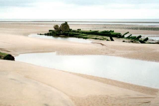
In 1914 he had attempted to prove his theory with an expedition to King Scar, where he saw curving stone embankments which he thought were probably man-made.
In correspondence with local fishermen Chris Ainsworth and Thomas Leadbetter, he was assured that the structures were very well known to them, and that the area was known to them as Roman Harbour.
Advertisement
Hide AdAdvertisement
Hide AdHe was convinced, and subsequently so were many others who read his account. In 1949 the Fleetwood Historical Society organised two expeditions to the site but were defeated by the tides and then in 1955 the Blackpool Sub-Aqua Club were planning to investigate but were warned off by experts because of the strength of the tides.
I visited the site on foot in 1995, and I flew over it to take photographs in 2013 when things had changed somewhat.
As late as 1995 Dr Shotter (now Emeritus Professor) and Andrew White in ‘The Romans in Lunesdale’ quoted ‘fascinating reports’ of submerged structures off the coast, but did at least say that the truth may never be known.
n Next week the trail takes a different turn in the hunt for Portus Setantiorum.