Lancashire braces for 'blizzard-like conditions' as Met Office issues countywide weather warnings


The Met Office has issued a yellow weather warning for large parts of Lancashire, including Preston, with 'blizzard-like conditions' expected on Saturday.
But northern and eastern parts of the county are being told to prepare for the worst of the weather, with an amber warning in place for Lancaster and Burnley.
Advertisement
Hide AdAdvertisement
Hide AdThe warning, which warns people to brace for 'blizzard-like conditions', will remain in place between 10am on Saturday to 6am on Sunday.
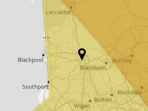
Blackpool lies just outside the yellow weather warning zone but is still expected to be hit by torrential downpours from 11am on Saturday.
Saturday
According to the Met Office, Friday's crisp air and bright skies will quickly turn cold and cloudy at dusk, before the worst of the weather arrives on Saturday morning.
The weekend is expected to begin with heavy winds and bitterly cold temperatures, with spells of freezing rain and the possibility of some snow.
Advertisement
Hide AdAdvertisement
Hide AdHeavy, freezing rain will develop during Saturday afternoon. This will result in the rapid formation of widespread ice on roads, pavements, trees and other structures.
According to the Met Office, freezing rain is rare in the UK, but when it does occur the impacts can be severe. Freezing rain can be very hazardous because it forms ground ice very quickly. Similar to black ice, it can become very slippery and is often difficult to see.
The wet weather will lead to 'blizzard-like conditions' and widespread ice over higher ground as the evening progresses. Maximum temperature of 4 °C are expected.
Some sleet and snow is possible over the very highest ground and the freezing rain may also be followed by a spell of sleet and snow as the precipitation clears from the west.
Advertisement
Hide AdAdvertisement
Hide AdThe freezing rain and sleet and snow will be accompanied by strong southeasterly winds which will pose an additional hazard to travel, in particular over high ground.
Sunday
After 24 hours of freezing rain, ice and a strong possibility of some snow over higher ground, the weather will likely become drier and less cold on Sunday, with perhaps just the odd shower hampering our Christmas shopping. Maximum temperature 7°C.
Next week
Sunday's milder weather could continue through Monday, but is expected to turn windier in the evening and continue to deteriorate through Tuesday with outbreaks of heavy rain.
What to expect this weekend
- Injuries from slips and falls and danger to life on icy surfaces are likely
Advertisement
Hide AdAdvertisement
Hide Ad- Black ice may form quickly affecting bus, train and air travel
- Dangerous driving conditions are likely leading to road traffic collisions, road closures and longer journey times
- Pavements and cycle paths likely to become instantly impassable because of the sudden formation of black ice
- Power and other services, such as telephone and mobile phone coverage, likely to be interrupted or cut
- Heavy, freezing rain is expected to result in the rapid development of widespread ice, with very dangerous travelling conditions likely.